Originally written for my Intro to Journalism course in November 2022.
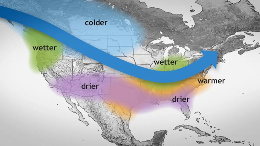
The weather has been surprisingly warm this fall, and La Niña and jet streams are to blame. La Niña is a phenomenon where strong winds displace warmer ocean water, causing colder layers to rise to the surface. By interfering with ocean temperatures and wind patterns, these atmospheric conditions disrupt climate patterns, ultimately bringing this hotter air up towards the Northeast.
Physics Professor Aileen O’Donoghue has been studying global climate for decades, and believes the current situation is being caused by cooler-than-normal temperatures in the Pacific Ocean. “So when we have La Niña, then it’s blowing stronger and so it pushes more of the hot water away,” she says. “And it gets stronger upwelling, so we have more cold water.”
Environmental Studies Professor Jon Rosales points out the relationship between the warm weather this fall and jet streams, or the wind currents caused by the intersection of warm and cold air. “Our warm temperature today has more to do with the jet stream than the planet itself heating up,” he says. “It’s where the heat is being moved by these upper level winds.”
Rosales explains the trajectory in which the warm air is carried towards the Northeast. “Today the jet stream is going straight down over Seattle, almost all the way to Mexico, and then back up,” he states. “And then as it’s going back up, it’s pulling all this warm air from the gulf up to us.”
O’Donoghue elaborates on how La Niña derails the jet stream’s path. “The polar jet stream gets deflected up toward Alaska and sinks down,” she says. “And it makes this curve in the continental U.S., and pulls the warmer tropical air.” This deflection in patterns results in uncharacteristic weather patterns, specifically heightened temperatures in our case.
Rebecca Jewell teaches at SLU, and having lived near Canton for 18 years, she has noticed the fluctuations in climate before. “I wouldn’t say I’ve seen a consistently steady increase in trends, it seems a bit more sporadic,” she notes. “But right now we’ve been experiencing warmer weather than at least last year’s Fall, where we got snow by October 31.”
La Niña is not caused entirely by climate change, but is rather amplified by these effects. Increased CO2 emissions alter atmospheric conditions by increasing the amount of energy in the air, according to O’Donoghue. “These big jet streams that steer the weather systems, they’re loopier because there’s just more energy in them, so that’s where our contributions of CO2 are doing it,” she states. “And that loopiness is part of global warming, but it’s also part of La Niña.”
O’Donoghue emphasizes the cross section between climate change and natural processes to better understand how both have influential, yet different roles in determining the current weather landscape. “It’s not that every day is 1.5 Celsius degrees warmer than the previous, it’s that there’s a lot more energy in the atmosphere,” she points out. “And if there’s more energy, there’s more activity.”
Jewell enjoys the warmer temperatures, but fears the bigger picture problem that might lurk beyond these current weather patterns. “When people bring it up in the context of are we seeing global warming, obviously it can be a bit of a fear or concern,” she says. “But I think mostly about how it’s not the dead cold of winter yet, so I’m thankful for the immediate effect.”
Looking ahead, is the upcoming winter bound for colder forecasts? Rosales thinks yes. “If I had to make a prediction, if this jet stream continues to be as wobbly as it is, we may have a longer winter,” he suggests.
On the flip side, O’Donoghue sees the difficulties in predicting winters while in the midst of La Niña. “Not all El Niño winters are the same, and not all La Niña winters are the same,” she points out. “These long term trends are still very hard to forecast.”


Leave a comment